Five Apps That Are Useful For Backpackers
Most of us who take to the backcountry aim to get away from the flash and buzz of our increasingly, sometimes overbearingly technological world. Nonetheless, a good piece of technology–whether it’s a hunting knife or a fancy GPS–can be incredibly valuable in the pack, and may even spell the difference between life and death in the event of an emergency. Smart-phone apps have opened a whole new arena in backpacking resources: You can now carry the equivalent of pounds of field guides and maps in an airy, immensely compact device. Here’s a look at a few of the most useful apps for backpackers on the market.
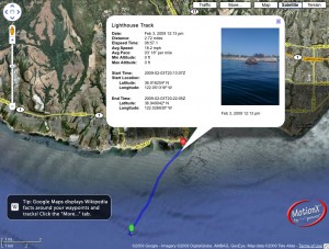
MotionX-GPS
This app gives you a virtual GPS unit for all your backpacking needs. You can access topographic maps for route-planning and route-finding, and track your course to log favorable routes and double-back to your starting point, with pertinent details like elevation profiles and travel speeds saved for reference. Mark notable landmarks or simply appealing vistas with the waypoint function, which can be augmented with a geotagged photo. You can even integrate with Facebook and Wikipedia to track down your social-media buddies’ favorite destinations and bone up on background information on places you’re exploring.
Peaks
Augmented Outdoors’ innovative app Peaks gives mountain trekking—as well as basic backcountry travel in rugged country—an engaging new edge: the ability to instantly identify surrounding summits. You simply point your iPhone camera at a nearby high point and instantly learn its name, elevation, and position in relation to yours. This makes it an excellent resource for orienting yourself and also an endlessly fun one. Peaks allows for augmented photos that will tag summits in the frame as well as that on which you’re standing. With an Internet connection, you can also access a map view for broadening your perspective and seeking out peaks in the vicinity.
GoSkyWatch Planetarium
One of the true joys of wilderness backpacking is the dazzling richness of the heavens canopying your nights out. GoSkyWatch Planetarium from GoSoftWorks helps you make sense of the wheeling constellations and blazing planets, which never look more bold than above a wild, inky-black landscape. It’s meant to be easy and straightforward to use in the field: You simply point above you to identify what you’re seeing right there and then, with a massive amount of supporting data at the touch of a finger. Knowing the locations and traverses of celestial bodies and patterns is also truly practical knowledge on the trail, and certainly comes in handy for emergency navigation.
Army Survival
You’ll feel a little more confident in the wilderness with the U.S. Army “Survival” field manual in the palm of your hand–and all the more so if you spend time studying it ahead of your trip. Chockfull of all manner of essential information for staying alive in the backcountry, this app, generated by Double Dog Studios, covers everything from fire-starting to first-aid. Hopefully you won’t ever need to worry about most of these contingencies, but you’re foolhardy not being prepared to deal with them should they arise.
iTrack Wildlife
Keying into the ecological intricacies of the wilderness areas you’re exploring while backpacking inevitably deepens your experience: Your trip becomes less an athletic feat and more an immersion in a complex and living landscape. One delight is the diversity of animal tracks you can run across—including those of rare and elusive beasts you otherwise would be unlikely to detect. iTrack Wildlife provides a comprehensive inventory of prints from over six dozen major North American mammals. This app is packed with information: Clicking on a black silhouette of a given species’ print takes you to a full tracking account, replete with numerous photographs of prints in different substrates, explications of gait patterns, a list of other animals that leave similar spoor, and general natural-history details. You’ll also be able to walk through more step-by-step track identification, as well as tackle the basics of measuring and recording prints.
All of these apps can deepen and expand your enjoyment of your backpacking trip. Just remember: Don’t skimp on the old-fashioned equipment, however impressive these virtual tools might be. The smart wilderness traveler always carries provisions for the unforeseen as well as multiple references–paper map, compass, GPS, smart-phone–to consider against one another when making route decisions.
Author Bio:
Guest post contributed by Carla Gregson for BingoStreet.com. Register at Bingostreet to play online bingo.


